|
|
SCIAMACHY overpasses - campaign sites
Current campaign: Cabauw, The Netherlands
| NOTES: |
| * On September 13, the Cabauw overpass will deliver no SCIAMACHY data, due to a planned orbit out-of-plane manoeuvre of Envisat. |
| * On September 7, 16:39 UTC, an anomaly occurred onboard ENVISAT which triggered a switch-off of the complete payload. SCIAMACHY was successfully switched on again at the end of 11 September. The Cabauw overpasses from 8 to 11 September have delivered no data for validation. |
|
 |
 |
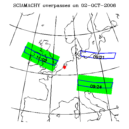
| Cabauw today |
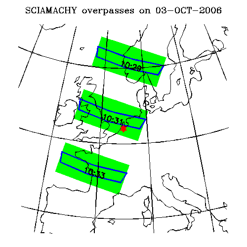
Cabauw tomorrow |
These pictures show the SCIAMACHY nadir (green) and limb (blue) measurements
of today and tomorrow near Cabauw (NL), where a validation campaign will be performed for NO2 and aerosol.
The observation times (UT) are indicated in the limb measurements, the
(closest) nadir measurements are performed typically 7 minutes later. Note
that the geolocation of the limb measurements is based on the projection of the
tangent heights. The actual observed air mass is larger.
Each block in the picture contains a series of nadir or limb measurements. The
ground pixel sizes for individual measurements depend on the orbital position
and the retrieved trace gas.
The nadir
measurements are used to derive trace gas columns of O3, NO2, SO2, BrO, OClO,
H2CO, N2O, CO, CO2, CH4, H2O, aerosols, UV index and clouds, the limb
measurements are used to derive trace gas profiles of O3, NO2, BrO, H2O, N2O,
CO, CH4, CO2, p/T profiles and aerosols.
The geolocation information is obtained from the SCIAMACHY operations web site.
Overpass maps for other days (Cabauw):
Overpass maps for 168 different stations:
EOR1
endif
if ( $qs == '' ) then
# define default date and station (De Bilt)
set station = "De_Bilt(52.1,5.2)"
set yyyy = `date +%Y`
set mm = `date +%m`
set dd = `date +%d`
# echo "$yyyy $mm $dd $hh $lon $lat
"
else
# extract date from the query string
# example : station=De_Bilt&yy=2000&mm=06&dd=15&hh=12&xax=partial_pressure&yax=height
#
#echo "$qs
"
set qs = `echo $qs | /usr/bin/tr "&" "=" | /bin/sed "s@+@@" | /bin/sed "s@%2B@@" | /bin/sed "s/%28/\(/" | /bin/sed "s/%29/\)/" | /bin/sed "s/%2C/\,/"`
set station = `echo $qs | /usr/bin/cut -f2 -d= | /bin/sed "s@%27@'@" | /bin/sed "s@%2F@/@" `
set yyyy = `echo $qs | /usr/bin/cut -f4 -d=`
set mm = `echo $qs | /usr/bin/cut -f6 -d=`
set dd = `echo $qs | /usr/bin/cut -f8 -d=`
endif
set yy = `echo $yyyy | /usr/bin/cut -c 3-4`
set nst = 1
set istation = 1
while ( $nst <= $nstations )
if( "${station}" == "${stations[${nst}]}" )then
set istation = $nst
set nst = $nstations
endif
@ nst ++
end
#
# Start form
#
echo ' '
echo ''
echo ' '
# End message:
set endmessage="\
\n\
$lastupdate\n\
This page is maintained by: Ankie Piters\n\
\n"
#
# Stop here if query string is missing
#
if ( $qs == '' ) then
echo $endmessage
echo '
| |
